How do I use Google Maps for my Florida Keys road trip?
Open Google Maps, input your start and end points (e.g., Miami to Key West), and add stops like Key Largo, Islamorada, or Marathon. The app will generate the most efficient route along the Overseas Highway, providing turn-by-turn directions, traffic updates, and estimated travel times. You can save your route offline.
What are the best beaches on the Google Map of Florida Keys?
Some top beaches visible on the Google Map of Florida Keys include Sombrero Beach in Marathon, Bahia Honda State Park near Big Pine Key, and Smathers Beach in Key West. Zoom in on these areas on Google Maps to see amenities, access points, and visitor reviews for parking and facilities.
Can I find live traffic updates for the Overseas Highway on Google Maps?
Yes, Google Maps provides real-time traffic conditions for the Overseas Highway (US-1). The map displays color-coded lines indicating traffic flow: green for clear, orange for moderate, and red for heavy congestion. This feature is crucial for planning your travel times and avoiding delays, especially during peak tourist seasons.
How do I locate popular restaurants and bars in Key West using Google Maps?
Simply search "restaurants Key West" or "bars Key West" on Google Maps. You can filter results by cuisine, ratings, and price range. Click on specific establishments to view their location, hours, menus, photos, and user reviews. This helps you find popular spots like Sloppy Joe's or Blue Heaven quickly.
Does Google Maps show specific points of interest and landmarks in the Florida Keys?
Absolutely. Google Maps highlights numerous points of interest, including the Southernmost Point Buoy, Ernest Hemingway Home, and the Key West Lighthouse. Search for specific landmarks or browse the map for icons representing historical sites, museums, and natural attractions. Each listing provides detailed information and directions.
Are there options for exploring the Florida Keys with Google Street View?
Yes, Google Street View offers immersive 360-degree panoramic views of many areas in the Florida Keys, including sections of the Overseas Highway, Duval Street in Key West, and various beaches. This is excellent for virtually scouting locations, checking out parking, or getting a feel for an area before you arrive.
How can I find boat ramps and marinas in the Florida Keys using Google Maps?
To find boat ramps and marinas, search "boat ramps Florida Keys" or "marinas Key Largo" on Google Maps. The map will display their locations, and clicking on a specific one often provides details like launch fees, dock availability, and contact information. This is invaluable for planning your boating excursions.
Navigating the breathtaking Florida Keys is easier than ever with Google Maps. Discover hidden gems, pristine beaches, and vibrant local spots from Key Largo to Key West. This comprehensive guide helps Gen Z and Millennials plan their ultimate Keys adventure, optimizing routes, finding the best dining, and exploring iconic landmarks with real-time updates. Whether you're road-tripping or seeking specific attractions, leverage advanced mapping features for an unforgettable journey. Stay ahead with trending local insights, ensuring every stop on your itinerary is perfectly mapped out. Unlock the full potential of your Keys experience, making every moment count with precise location data and community reviews.
- How do I best plan a Florida Keys road trip using Google Maps? - Utilize Google Maps to plot your journey from Key Largo to Key West, incorporating stops for scenic views and attractions. Input multiple destinations to optimize your route along the Overseas Highway. Real-time traffic updates and estimated travel times are crucial for a smooth trip, helping you avoid delays and discover key points of interest efficiently.
- What are the top must-visit spots in the Florida Keys on Google Maps? - For unforgettable experiences, Google Maps guides you to <b>Bahia Honda State Park</b> for stunning beaches, <b>Robbie's of Islamorada</b> for tarpon feeding, and <b>Mallory Square</b> in Key West for sunset celebrations. These locations are highly rated and offer unique Keys charm. Use the map to check current hours and navigation details for each.
- Can Google Maps show real-time traffic on the Overseas Highway in Florida Keys? - Yes, Google Maps provides live traffic conditions for the entire Overseas Highway (US-1). Color-coded lines indicate traffic flow, helping you identify congestion and choose alternative routes if necessary. This feature is invaluable for planning your drive times, especially during peak seasons or busy weekends, ensuring a smoother journey through the Keys.
- How can I find pet-friendly locations in the Florida Keys using Google Maps? - To find pet-friendly spots, search Google Maps for "pet-friendly restaurants Florida Keys" or "dog parks Key West." Filter results, check business details for specific pet policies, and read reviews from other pet owners. Many outdoor cafes and some parks welcome leashed pets, making it easier to travel with your furry companions.
- What's the best way to find parking in Key West with Google Maps? - Google Maps can help locate parking garages and lots in Key West. Search "parking Key West" to see available options, including the Old Town Garage or Mallory Square parking. Check for real-time availability or pricing details where provided. For street parking, zoom in to identify metered spots and understand time restrictions before arriving.
- Does Google Maps offer walking or cycling routes for Florida Keys attractions? - Yes, Google Maps provides walking and cycling directions for many areas within the Florida Keys, especially in towns like Key West. Select the walking or cycling icon after inputting your destination to see path options, elevation changes, and estimated times. This is perfect for exploring local neighborhoods and scenic routes at a slower pace.
- How accurate are business hours on Google Maps for Florida Keys establishments? - Business hours on Google Maps are generally highly accurate as they are often updated directly by businesses or verified by user contributions. However, it is always wise to double-check by calling ahead or visiting the establishment's website, especially for smaller businesses or during holidays, as hours can occasionally change unexpectedly.
Ready to explore the stunning Florida Keys? Forget the guesswork. Your ultimate adventure from Key Largo down to Key West is perfectly mapped out with Google Maps. This guide cuts straight to what you need to know, helping you discover the best spots, navigate effortlessly, and make the most of your trip. Let's dive in.
Frequently Asked Questions
Where are the absolute best photo spots in the Florida Keys?
The best photo spots are Sombrero Beach in Marathon, Bahia Honda State Park for bridge views, and Mallory Square in Key West for sunset. Don't miss the iconic Southernmost Point Buoy too. Capture those unforgettable Keys vibes.
How do Local Maps help with real-time navigation and busy hours in the Florida Keys?
Pull up your preferred mobile Maps app to verify real-time hours, as peak weekend times fill up fast. Local MAPs provide live traffic, road closures, and optimal routes. Check business hours and crowd estimates directly on Google Maps before you head out, especially for popular restaurants and attractions.
What are the best times to visit and avoid parking headaches in the Florida Keys?
Visit during the shoulder seasons (late spring or early fall) for fewer crowds. For parking, aim for early mornings or late afternoons. In Key West, consider:
- Park & Ride Garages (e.g., Old Town Garage)
- Side streets off Duval (metered)
- Designated parking lots near popular attractions
- Key Largo Fisheries Backyard Cafe: Key Largo (MM 99.5 B/S)
- Robbie's of Islamorada: Islamorada (MM 77.5 B/S)
- Dolphin Research Center: Marathon (MM 59 G/S)
- Bahia Honda State Park: Big Pine Key (MM 37 O/S)
- Ernest Hemingway Home: Key West (Old Town)
- Mallory Square: Key West (Historic Seaport)
All maps focus on google map of the florida keys.
Explore Florida Keys with Google Maps, find best beaches, dining, attractions, plan road trips, real-time navigation, local insights from Key Largo to Key West.
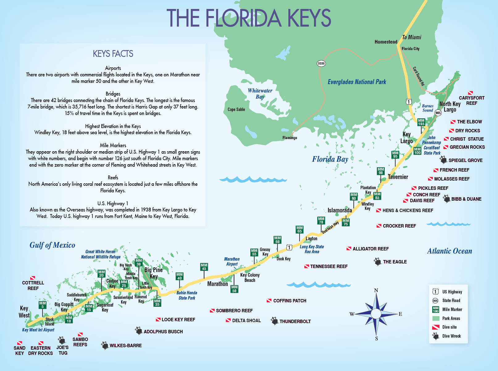


Navigating Paradise Unveiling The Florida Keys With Google Maps All Map Converted Islands Of Top Must See Places In Tourist Zarla Detailed Max Download Them And Print.


Printable Map Of Florida Keys Tourist And Key West Real Estate Information With Mile Markers Google FL Floridakeys Maps A Complete Guide To Islands Routes E8EBCAB3 0B7F 4b81 AD37.


Florida Keys Map Pdf Printable Free Templates Road Trip From Miami How Many 25M Lengths In A Mile Complete Guide Key Details TAFT Markers Of The With Maps West And Beach 411 Travel Store For Stops To Make Largo.


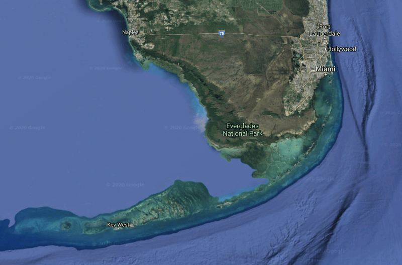
Miami Sightseeing Map Photos Arptravels Com Of Florida Keys With Route And Infographic 2STGD4M Adventures Your Ultimate US Guide BWUI35MGLR P173 World Maps Library Complete Resources Google The 2TRAVELDADS Inside Navigating Paradise Unveiling FL Aerial.


Google Maps Florida Keys Map Of Where Are The Reefs In Fishing Snorkeling Key West Mile Markers With Show Set Location Political Borders And Facts.


Printable Florida Keys Map Download Free Templates Maps Vintage Of The Photograph By Andrew Huisman Pixels Google Sorry If This Is A Strange Question But What Exactly Within Earth Fishing Reef Overview Pertaining To Parkland Location Political Borders And Facts Satellite State Scaled.


Maps Of The Florida Keys Key West Map Printables Templates Free Google Detaild Road And Travel Vector Stock Detailed Islands Printable Attractions Photos Com.